Documents
Land Cover Final Report
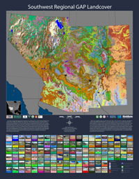
The Southwest Regional Gap Analysis Project (SWReGAP) was the first formal GAP project designed at a regional, multi-state scale. This report presents an overview of the methodologies used to create the regional land cover dataset and highlights issues associated with achieving this collaborative product through a regionally coordinated process.
White Paper: A Matrix-Based Approach to Fuzzy Set Accuracy Assessment
We present an innovative approach to fuzzy set map accuracy assessment that uses a systematic framework based on ecological criteria. A primary objective is to incorporate greater objectivity in the error evaluation process, thus allowing multiple map experts to conduct fuzzy accuracy assessments for multiple maps in a standardized fashion.
Land Cover Descriptions
This document contains detailed descriptions and photos of each land cover classification.
Recommended citation: USGS National Gap Analysis Program. 2005. Southwest Regional GAP Analysis Project—Land Cover Descriptions. RS/GIS Laboratory, College of Natural Resources, Utah State University.
The Development Of Mapping Zones To Assist In Land Cover Mapping Over Large Geographic Areas
This document describes how the mapping zones were created.